

The Montgomery/Grimes county fire is rapidly growing in size & speed. The news said that it running through the tops of the pine trees and they have now expanded the mandatory evacs.
3000 ac on fire
View Larger Map


UPDATE 9/5/11 1726
A mandatory evacuation order was issued for some Grimes and Montgomery County residents Monday afternoon after a wildfire threatened nearby homes. The evacuation order was issued for the Lake Hollyhill subdivision in Grimes County, near FM 1774 -- south of CR 302 and north of Riley Road.
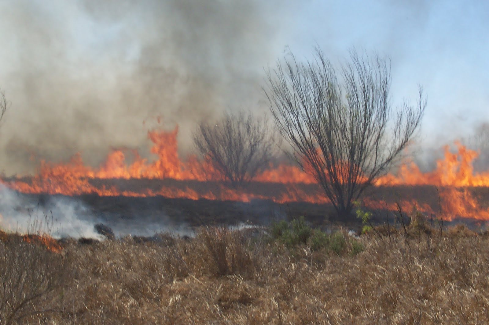
Right now we are smelling the smoke from the wildfires. Most are burning to the far north & west of Livingston.

Navarro, TX

NACOGDOCHES COUNTY, Texas


Centerville, Tx

Ft. Worth

BASTROP COUNTY COMPLEX, Bastrop County. 14,000 acres, no containment. Heavy airtankers and single-engine airtankers assisted on this fire that started in the Lost Pines area just northeast of Bastrop. The fire has moved unchecked for at least 16 miles to the south and has jumped the Colorado River twice. The Circle D, K.C. Estates, Pine Forest, Colovista and Tahitian Village subdivision have been evacuated. Firefighters are trying to hold the fire at FM 2571. Reports indicate possibly 300 homes have been destroyed. MODIS satellite image indicates the fire has jumped Highway 95 and is approximately 25,000 acres.
STEINER RANCH, Travis County. 150 acres, no containment. The fire started just north of the Steiner Ranch subdivision. More than 1,000 homes are under mandatory evacuation in Steiner Ranch. At least 25 homes are reported lost. A Texas Intrastate Fire Mutual Aid System strike team responded.
PEDERNALES BEND, Travis County. 7,000 acres, unknown containment. The fire is burning four miles southeast of Spicewood. Twenty homes were lost, 30 homes damaged.
HENDERSON #495, Henderson County. 5,000 acres, unknown containment. Three homes were saved.
#491, Limestone County. 3,000 acres, unknown containment. Six homes were saved and one was lost on this fire 20 miles east of Waco.
DELHI, Caldwell County. 1,000 acres, 10 percent contained. Twenty homes were saved and six were lost on this fire east of Lockhart.
BAILEY, Colorado County. 1,000 acres, unknown containment. This fast-moving fire threatened 40 homes near Columbus. Blackhawks, single-engine airtankers and a heavy airtanker assisted.
MOORE, Smith County. 927 acres, 5 percent contained. Ten homes were evacuated and five were lost on this fire burning on the Smith/Gregg County line. Two civilian fatalities were reported.
#545, Upshur County. 500 acres, 50 percent contained. One hundred homes were saved; none lost. The fire is burning East of Gilmer.
LUTHERHILL, Fayette County. 2,000 acres, unknown containment. The community of Ruttersville was evacuated. Seven homes are reported lost.
BONBIEW RANCH, Van Zandt County. 350 acres, unknown containment. Twenty homes were saved southeast of Canton.
CLEMANIS, Upshur County. 400 acres, 85 percent contained. Twenty homes were saved.
#543, Gregg County. 300 acres, unknown containment. Numerous homes were saved, none lost.
#538, Harrison County. 200 acres, contained. One hundred fifty homes were evacuated in a trailer park east of Longview.
#502, Nacogdoches County. 200 acres, unknown containment. More than a dozen homes have been evacuated, but none lost.
#841, Houston County. 200 acres, unknown containment. Fifteen homes were threatened east of Crockett.
PLEASANT GREEN ROAD, Gregg County. 150 acres, contained. Numerous homes evacuated and saved south of Longview.
KENNEDY ROAD, Rusk County. 150 acres, unknown containment. Numerous homes threatened, one lost.
HODDE, Travis County. 325 acres, contained. Two hundred homes were evacuated and saved east of Pflugerville. No homes reported lost.
PETTYTOWN, Caldwell County. 200 acres, 90 percent contained. Twenty homes were saved east of Lockhart.
OLD MAGNOLIA, Gregg County. 100 acres, unknown containment. No homes threatened. Two fuel tanks exploded.
SOUTH SULPHER, Hunt County. 100 acres, 70 percent contained. Five homes were threatened and two were destroyed.
#839, Leon County (Concord Robbins). 100 acres, unknown containment. At least 15 homes are reported lost and more than 300 were evacuated.
Uncontained fires from previous days (more than 100 acres in timber, 300 acres in lighter fuels):
*Note: No current updates available except on the 101 Ranch Fire.
101 RANCH, Palo Pinto County. 6,555 acres, 75 percent contained. The fire is burning on the south side of Possum Kingdom Lake near the town of Brad. Thirty-nine homes and nine RVs have been reported destroyed.
CRAB PRAIRIE, Walker County. 977 acres, 90 percent contained. Numerous SEATs and helicopters, as well as National Guard bulldozers assisted. Two homes were reported to be lost.
HORNETS TANK, Briscoe County. 5,500 acres, 90 percent contained. The fire is burning in juniper and grass in rough terrain near Palo Duro Canyon.
CEDAR RIDGE, Bosque County. 903 acres, 75 percent contained.
3547 ROAD, Wise County. 400 acres, 80 percent contained. Approximately 60 homes were evacuated near this fast-moving fire. Five homes were lost.
JOHNSON (JACKSON) RANCH, Edwards County. 600 acres, 95 percent contained. Three homes were lost on this fire burning 27 miles northwest of Hunt.
BIG DRAW, Kimble County. 600 acres, 20 percent contained. Active fire behavior in heavy fuels and steep terrain was observed. Twenty homes are threatened.
RICK RANCH, Sutton County. 395 acres, 95 percent contained. The fire is burning 24 miles west of Junction.
JACK MOUNTAIN, Coryell County. 1,700 acres, 60 percent contained. The fire is burning five miles south of Gatesville on the Ft. Hood military reservation.
BUNDY ROSS RANCH, Edwards County. 600 acres, 75 percent contained. The fire is burning in juniper, grass and brush 7 miles southeast of Telegraph.
DOUBLE T, Menard County. 300 acres, 95 percent contained. The fire is burning 19 miles west of Brady.
PICKET RUN, Montague County. 1,100 acres, 90 percent contained. The fire is burning in tall grass 7 miles south of Bowie.
CEDAR TRUCK COMPLEX, Kimble County. 357 acres, 80 percent contained. Thirteen homes were saved on this fire burning just west of Fort McKavett. This was a combination of 34 different starts along a 24-mile stretch of highway.
COSTER, Hall County. 1,000 acres, 80 percent contained. Four homes were saved on this fire burning 26 miles northwest of Childress.
HORSESHOE BEND, Coryell County. 525 acres, 75 percent contained. The fire is burning 10 miles south of McGregor. National Guard Blackhawks assisted on the fire. Twelve homes were saved.
Bastrop, TX


